Shire of Nungarin
 |
 |
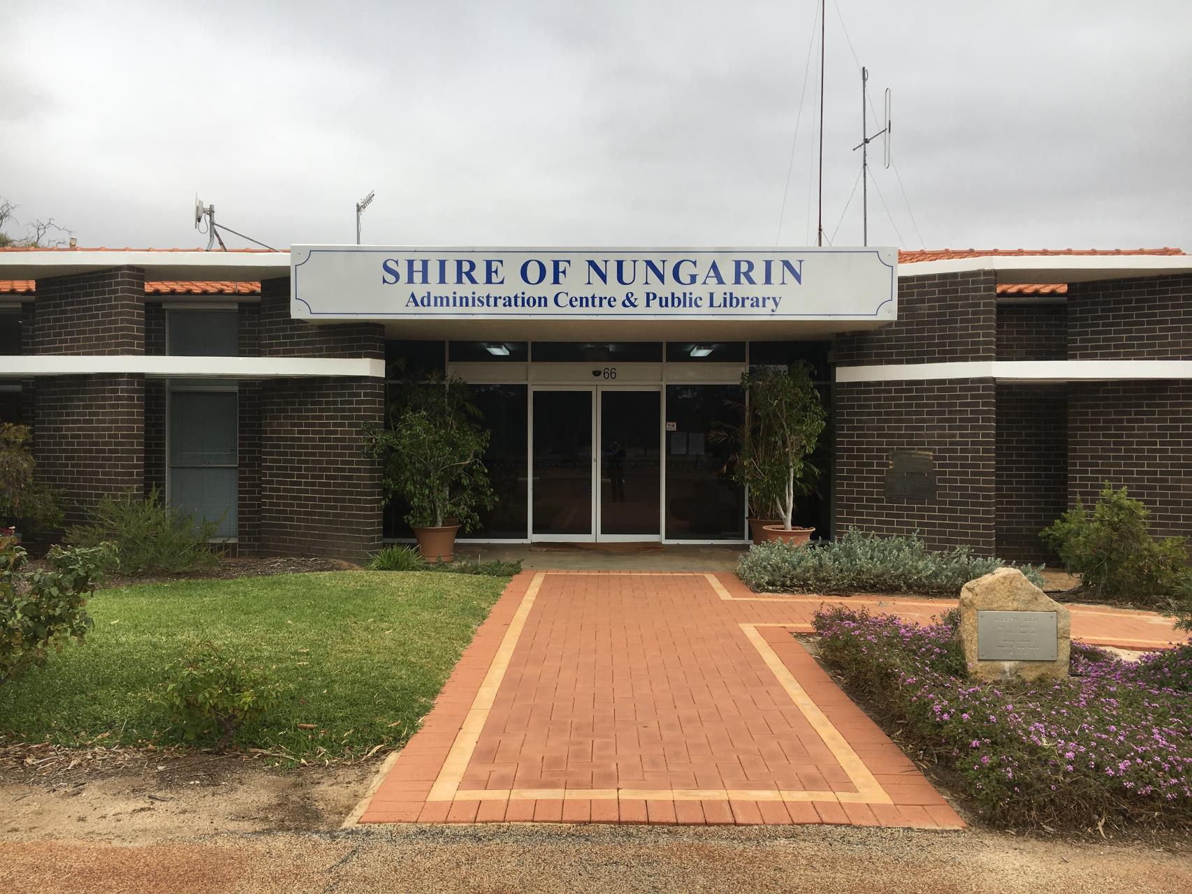
| Shire of Nungarin Office (Present Day) |
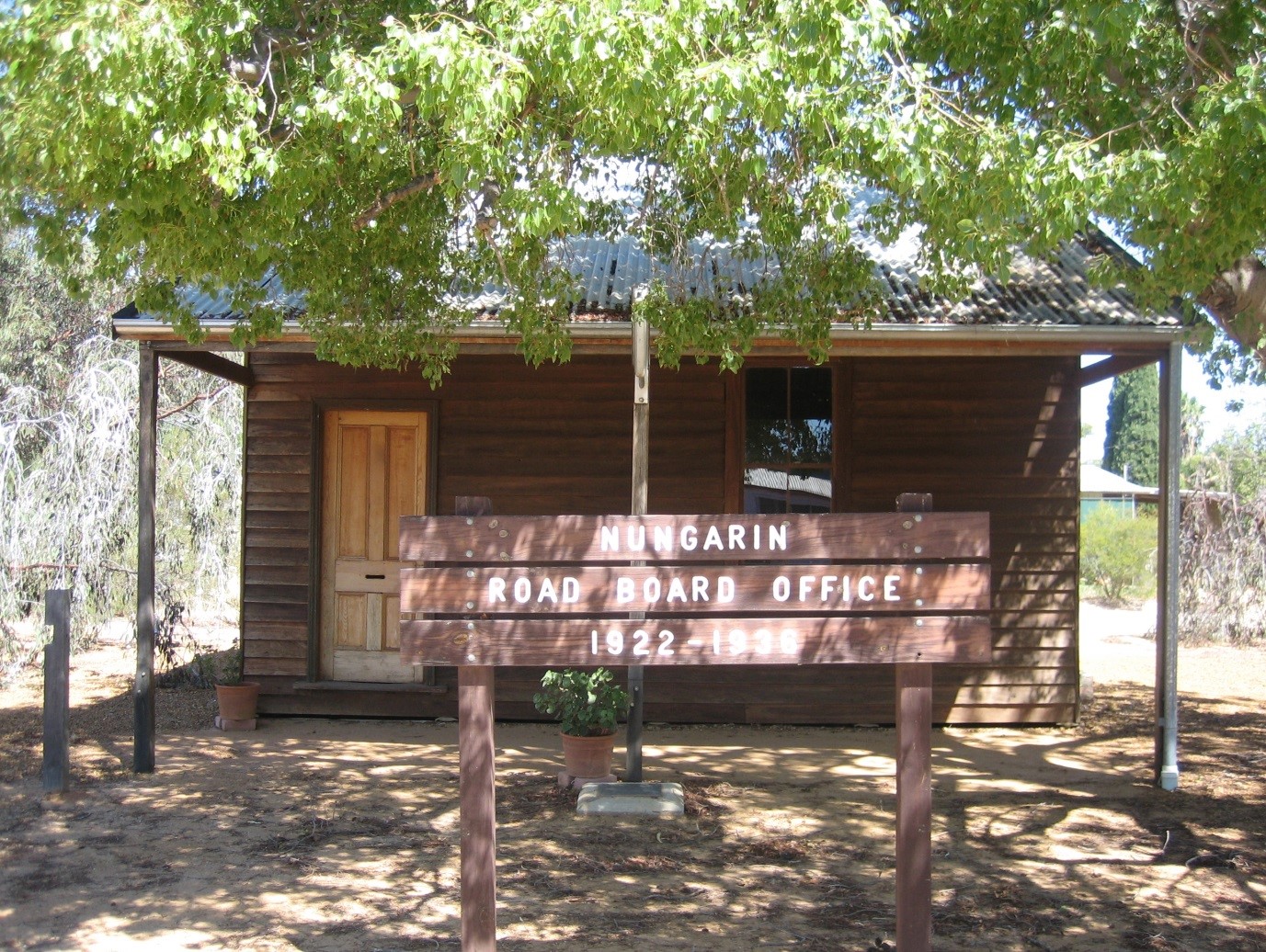
Nungarin Road Board Office (1922 - 1938) |
A Little Bit of Nungarin History
Statement of Significance
This building has been classified by the National Trust. Recommended for entry into the State Register of Heritage Places Recommended protection under Town Planning Scheme. At one time the building had been restored and furnished. Recommended that restoration be upgraded and the building be included in an integrated tourism plan for Nungarin.
Physical Description
The building consists of a single room of weatherboard with a corrugated iron roof which overhangs on the front side to form a verandah. It has a sheet metal fireplace and chimney at one end, is timber lined with a timber ceiling and wooden floor. Some boards have been damaged by white ants. In 1991, a time capsule was buried in front of the building to commemorate the 70th anniversary of local government in Nungarin. A plaque with the following wording is attached: NUNGARIN SHIRE COUNCIL IN COMMEMORATION OF SEVENTY YEARS OF LOCAL GOVERNMENT 1921-1991 This plaque was unveiled on 24.8.1991 By Shire President, Barry Neyle Cornish. A time capsule has been placed below this plaque To be opened On the centenary of Local Government in Nungarin In the year two thousand and twenty one.
History
Water has always been a precious and rare commodity in this country. The availability of water dictated where aboriginal encampments would be, where stock could graze, and where settlement was possible. The path of human exploration has followed a path of wells and waterholes. It was the lack of water, and the expense when it was available, that led to the formation of the Nungarin Progress Association in 1911, and the harbinger of local government. Water was being brought in by train at a cost of six shillings per thousand gallons, and the Progress Association made a deputation to Parliament for the extension of the Goldfields Water Scheme.
During the 1870s when Charles Adams became the first settler in the district, Nungarin was part of the Toodyay Road Board. In 1895, the Nungarin area was included in the area administered by the Goomalling Road Board. Administration subsequently passed to the Kellerberrin Road Board in 1908, and then to the Merredin Road Board on 30th June 1911. At this time the interests of the Nungarin settlers were represented by Messrs W.S.Hodges, and R.G.Bagot. In 1917 the Nungarin Farmers and Settlers Association raised the possibility of establishing a local Road Board, as the settlers had many grievances against the Merredin Board. The roads in the district were in a very poor condition, and lacked maintenance. Travel was hindered as horses and cars alike were susceptible to bogging, and the carting of goods became an unnecessarily lengthy process.
A deputation comprising Mrs Hancock, Hodges, McCorry, Mann, Reddrop, J.R.Baird, Jolly and Jones saw the Clerk in charge of local government to present their case, and in February 1921, a proposal to redistribute the boundaries of the Merredin Road Board District appeared in the Government Gazette. The electoral roll for the Nungarin Road Board District was prepared on July 4th, and elections for the new board were held on August 6th. The Board was divided into five wards: Nungarin, Danberrin, Lake Brown, Mangowine and Wattoning. The first meeting was held in the Agricultural Hall on August 19th, 1921, and a dance was held that night to celebrate the occasion.
The first Nungarin Road Board covered a large area of about 517 998 hectares, but the Board quickly began to look after the advancement of the district. Dams and roads were upgraded, and tenders for horse and dray work were called for. The Board was concerned about the proliferation of rabbits and other vermin, and enforced regulations to control the problem. In 1922, the first Road board Office was erected in Mitchell Terrace at a cost of £196. As farming properties were developed to the north of Nungarin, there was increasing dissatisfaction with local government representation from those in more remote areas. The northern parts closer to Mukinbudin produced the most wheat, and needed more roads and water supplies, but were constantly outvoted by the Nungarin representatives. The Lake Brown area had been settled by returned soldiers after the first World War, and the early 20s were difficult years as they struggled to establish and develop their properties.
At the end of 1921, the Nungarin Road Board had adopted the ward rating system, which meant that only funds raised in each ward were available to be allocated for works within that ward. This policy had immediate ramifications in these struggling areas. Roads in the northern area were little more than rough tracks, and as settlers found themselves unable to pay rates, the Road Board was not able to allot funds for road works. At the annual ratepayers meeting in April 1925, J.Mulqueeny and T.Pain (both returned soldiers settled in the Lake Brown area) proposed a motion of no confidence in the Nungarin Road Board. The following year, settlers in the Lake Brown-Mukinbudin area first brought up the suggestion of a separate road board for the northern region, with the administrative centre in Lake Brown.
By 1927, representation on the Road Board had increased to eleven. Two members from each of the Nungarin, Danberrin, Mangowine and Lake Brown Wards, and three from Wattoning. The balance of power shifted after the 1932 elections when Mr.J.Ferguson of Dandanning defeated the sitting member, Mr F.Williams of Mangowine. This change gave the Mukinbudin faction 6 votes as opposed to 5 for Nungarin. With the change came the realisation that Mukinbudin now virtually had control of the board, and new possibilities presented themselves. Agitation now became focussed on maintaining a single local government body centred in Mukinbudin. At a Road Board meeting on July 11th, 1932, Mr H.Hansen moved, Mr E.B.White seconded, that the administration centre of the Nungarin Road Board be moved from Mukinbudin to Nungarin. There were immediate amendments from the Nungarin members, but ultimately the Mukinbudin faction won the vote with Mrs Mulqueeny, White, Hansen, Calder, Conway and Ferguson defeating the five Nungarin representatives, Hodges, Jolly, Hoare, Horn and McCorry.
Mukinbudin pressed home their advantage by immediately moving that an application be made to the lands Department for two blocks in the Mukinbudin townsite, and that a committee of three be elected to investigate the financing of new offices there. The next few months saw dramatic action as board members and ratepayers promoted various views. There were public meetings throughout the district. There were Road Board resignations, retractions, walkouts and delegations. Some parties favoured one single government body, with the centre variously proposed to be sited in Nungarin, Mukinbudin or Lake Brown. Some preferred two separate districts, but still contested whether the northern seat of administration should be Lake Brown or Mukinbudin.
Bonnie Rock ratepayers were concerned about how a separation would affect any later claim they may have to form their own district. Local feelings ran high, and with rumours about a proposal to "highjack" the Nungarin Road Board building, a group of Nungarin settlers mounted an armed guard to prevent the building being shifted. Ultimately it was decided to separate the district, and on 1st September 1933, the Government Gazette advertised that portions of the Nungarin Road District would be severed and reconstituted as the Mukinbudin Road District. Boundary negotiations continued for several years, and in 1938, after refusing to licence his vehicles in Mukinbudin as a protest, Mr M.J.Pink succeeded in having Avon Locations 14086 and 21462 transferred back to Nungarin. In 1940, a small portion of land at Mangowine (30 acres of Avon Location 13792) was also returned to the Nungarin District.
The old Road board building served as the administrative centre for the Nungarin Road Board between 1922 and 1936, when the new Road Board Building (now the Alice Williams Memorial Building) was completed in Railway Avenue. Toe H meetings were held in the building after the Road Board moved to the new offices in 1936, and at one time the building also housed a library. Toe H is a Christian organisation that had its foundation in Europe in World War One. The Branch in Nungarin was an active force in helping those in need by doing a variety of tasks such as chopping firewood and cleaning yards, offering friendship, visiting Kununoppin Hospital and collecting books for the library. The Branch eventually disbanded in the late 50s. Because of overcrowding at the Nungarin School, the Road Board building also served as an extra classroom between 1950 and 1952.
Address
Shire of Nungarin
66 Railway Ave
NUNGARIN WA 6490
PO Box 8
NUNGARIN WA 6490
Office Hours
Monday – Thursday 8.00 am – 4.30 pm
Friday 8.00 am – 4.00pm